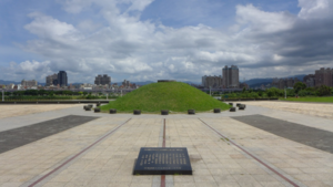
馬場町紀念公園
出自 淡水維基館
基本資料[編輯]
類型 公園 位置 臺北市萬華區水源路及青年路口 面積 6.8公頃 建成 2000 年 開放時間 全年 狀態 全天開放 停車場 第一果菜批發市場堤外停車場
簡介[編輯]
馬場町為台灣日治時期台北市之行政區,該町主要是軍事訓練之「台北練兵場」,用來操練步兵和騎兵之用,當時練兵場也作機場使用,相對於松山機場,所以又稱為「台北南機場」。該町約為今日萬華區南部濱新店溪之區域,青年公園(原練兵場)一帶,今中華路二段、泉州街(崁頂)、水源路之一部均在町內。即今青年公園、南機場國宅一帶。
馬場町的河堤邊是戒嚴時期用來槍決白色恐怖時代犧牲之政治犯的著名刑場。80年代,這裡改變成「跑馬場」,飼養馬匹,也訓練馬術人員,但多是官家使用。1998年,時任台北市長陳水扁決定在馬場町、六張犁設立「白色恐怖紀念公園」,以紀念白色恐怖時代犧牲之政治犯。2000年,位於馬場町之紀念公園落成,台北市長馬英九定名為「馬場町紀念公園」。2020年3月6日,臺北市文化局以「馬場町刑場」將公園登錄為史蹟。
現在的馬場町紀念公園已不復見當年的森嚴和肅殺,可以在這裡騎單車,欣賞新店溪河岸景觀、看夕陽、溜狗散步,成為市民的休憩寶地。
園內設施[編輯]
河濱自行車道
停車場:位於本園東北方的一座小型平面停車場。
連接天橋:連結青年公園,方便人民在這兩座公園移動。(有電梯,人與腳踏車都可以同時搭乘。)
地圖[編輯]
讀取地圖中...
相關影片[編輯]
- 影片描述: 空拍紀錄 馬場町紀念公園
- 影片來源:YouTube
