青田七六
出自 淡水維基館
簡介[編輯]
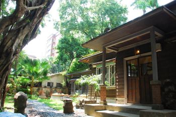
青田七六,其實就是「青田街七巷六號」的簡稱。
這棟於日本昭和年代由足立仁教授所設計之日式房舍,採洋和混和的建築模式;建築形式為高床式建築,下方空間曾用來養殖動物。曾居住過的名人有出身於日本北海道的足立人教授、以及國際知名地質學家馬廷英教授。
青田七六並非由公家經營管理,此屋屬於國立臺灣大學校產。臺大地質系校友因不捨老屋無人居住後漸漸頹及荒涼,向臺灣大學申請取得經營權租下此屋。目前早上提供老屋的文化導覽服務,中午開始到晚上提供餐點。平時在空間使用上因屋內保有馬廷英教授遺留下來之研究用具以及結果,藉此進行地球科學的教育。現經營團隊希望能將這棟古蹟活化再利用,介紹老屋歷史與建築特色並推廣地質科學,期待更多人能親近這棟美麗的日式屋舍。
歷史沿革[編輯]
- 1931年:由日本北海道的足立仁教授所設計的青田七六建築落成。
- 1945年:日本投降後,馬廷英教授來臺並向足立仁教授購買此房屋。
- 2006年:青田七六成為市定古蹟。
- 2009年:馬家人全部搬離。
- 2010年:建築物進行修繕作業。
- 2011年:修繕作業完成,古蹟餐廳「青田街七六」開幕。
交通地圖[編輯]
- 地址:臺北市大安區青田街7巷6號。
- 交通方式:1.捷運東門站5號出口,步行約15分鐘,沿永康街左轉金華街,再至青田街右轉。
- 2.捷運大安森林公園站2號出口,步行約15分鐘,沿新生南路直行至清真寺旁青田街七巷右轉。
讀取地圖中...


Leaflet | © OpenStreetMap contributors
